
Storm Midweek Sets Changes in Motion to Cold
Patience is a virtue and patience is thin for most. Winter, as mentioned a few times, has been anything but boring for our region. Winter weather lovers are becoming impatient and annoyed with the pattern we have been in, but last Sunday afternoon into Tuesday was the first step in the evolution to a drastically different weather pattern. Yes, Thursday and Friday could be considered “more of the same” but wild swings are what often occurs when the weather wants to change. Saturday turned out to be another nice day and Sunday will follow suit; however, the gears are shifting for another shot of winter to slam back into the region by the middle to end of next week. What makes this storm different? The rebound to balmy weather will not occur. Trending neutral to negative Arctic Oscillation (AO) and neutral to slightly negative North Atlantic Oscillation, plus a substantial strong stratospheric warming (SSW) event are signs that winter wants to make a charge into the eastern half of the United States.
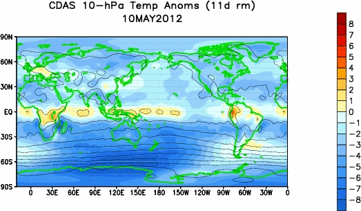
Stratospheric Warming At 10 Millibar Level; Courtesy of NCEP
The above map indicated temperatures at the 10 millibar level. This is at the lower end of the stratosphere. When dramatic warming takes place, warmth surges towards the North Pole with the polar vortex and jet stream pushed farther south. The farther south movement usually leads itself to a Polar Vortex in Canada thus flooding air into the United States. Now this does not always mean cold air will be placed over the Ohio Valley, but with trends forecasted by the NAO and AO to go neutral to negative along with the trends of an Eastern Pacific Oscillation (EPO) heading down to the negative side, this favors cold into the central and eastern United States. Modeling wars are occurring but the general trend is for the cold to establish itself. Once the features are in place, a better handling will be found with the models. Until then except wild solutions to continue.
We have to get through the next few days before winter comes knocking. For Sunday expect clouds to filter in and out during the day. Lows tonight will fall into the middle 20s to near 30 with afternoon highs in the lower to middle 40s. In the southwestern reaches with more sunshine a run at 50 degrees is possible. The start of the workweek looks great. With a good amount of sunshine, lows will stay mainly in the upper 20s to lower 30s for Monday and Tuesday morning with highs reaching the upper 40s to low 50s Monday, potentially the middle 50s on Tuesday in parts of the south. Things begin to change Tuesday night.

As mentioned in a prior post, I explained that the GFS often rushes too much energy out and leaves more energy behind. This appears to be the case. Over the last few days the midweek storm was forecasted to bring a slug of moisture up to the region with rain and some left over snow. What appears to happening is the first wave will be weaker as it wants to wait for the stronger northern branch to move into the central United States. It is with that piece that a stronger storm will organize and push northeast establishing two things. The first part will help push warm air up and east of the Appalachian Mountains aiding in cold air being pushed down behind the surface low. Secondly, with a stronger northern branch of energy it will help establish a surface low in southeast Canada which will lead to the likelihood of a Polar Vortex setting up shop. Specifics are too far out at this point and some small changes will occur but the winter pattern flip that I called for around the 15th of January are taking shape.
At Day 15 the Polar Vortex is sitting out in its semi-permanent home around Hudson Bay in Canada. If you follow the 500 millibar height lines up into central and northwest Canada, you end up at the polar region. This term is known as “cross polar” flow. It is air that comes up and over the top of the pole, down through Canada and into the United States. That source of air often originates in Siberia in northwest Russia where temperatures often run in the -50 to -60 degree Fahrenheit range. If enough support is established this pattern can often lock bringing extended periods of Arctic air into the region. I am not ready to say this will occur for weeks on end but agreement is starting to come in that a solid period of bitter air wants to invade the Ohio Valley region. Get ready for some cold weather, along with snow chances!
For instant updates check me out at twitter @ http://twitter.com/OhioValleyWx or on facebook @ http://www.facebook.com/OVWeather

You must be logged in to post a comment Login