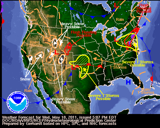
The brief warm surge that most of the Midwest and Ohio Valley experienced for four days has exited. What the region has experienced for the most part since late March is a pattern of slow moving storm systems that provide days of scattered showers and thunderstorms. This will be the case this coming week with a chance of rain each day for the next six days. An upper level low, currently located over the Midwest will drift east and even stall at times.
The map above is a view of the mid levels at 18,000 feet. This area of the atmosphere is the driver that steers storm systems across the United States. Saturday morning the upper level low was located over southeastern Illinois. As we progress to Sunday morning, the low crawls east to around Cincinnati, Ohio. Over 24 hours the low moves roughly 130 miles. The map below shows the position of the low tomorrow morning.
Courtesy of NCEP
A chief region why the low is meandering east is because it is deepening on its eastward progression. The combination of high pressure off to the east coast of the United States and the low deepening will cause the low to become cut off of the main flow resulting in it sitting over the region.
Courtesy of NCEP
Looking at Tuesday morning, the feature resides just east of Cincinnati. Looking at the jet stream, the northern branch is well to the north and the southern branch is well to the south. With no steering currents the low is forced to sit and spin over the Ohio Valley region until something comes along to kick it out. The closest energy source that could possibly push this storm out of the way is just entering the west coast of the United States on Tuesday, so expect days of the same unsettled weather conditions. Scattered showers and thunderstorms will be possible at any time but there will be periods of dry weather, so no day should be a wash out; however, bring the umbrella at all times.
Fast forwarding to Thursday, the western storm system begins to pivot east kicking out the pesky low that had been over the region for over 5 days. The problem with this scenario is by the time the low is located over central Pennsylvania, return flow from the Gulf and the low located over the four corners region will already begin to have influence on the Midwest and Ohio Valley region, thus the continued threat for showers and possible thunderstorms.
Courtesy of NCEP
Finally by this time next week, the western storm system is expected to wash out and a ridge of high pressure tucks in over the east. This will cut off the rain chances and allow for some sunshine. With stagnant weather patterns confidence is not as high so check back at www.myweathertech.com for the latest updates concerning the weather for the Midwest and Ohio Valley.
Temperatures this week will be well below average for highs. On Monday and Tuesday temperatures will be as much as 20 degrees below normal in some places across the region. With clouds and rain chances lows will be near or slightly above normal. Bottom line is a damp, raw, chilly week for most of the Ohio Valley.
As always keep it here at www.myweathertech.com for the latest updates.
By Weather Specialist Josh Ketchen